Saturday, July 14, 2007

10 July, Cassiar Highway and 10,000km mark

10 July


Cassiar Highway (at least in part), and Stevie rackes up 10,000km on North American soil (literally!)


I arose early for a change to pack the bike up for a reasonable start. I bid fond farewells to Bob and Louise and made my way over to the bike shop to get the new rear tire by 9:00am. The place was in a bit of chaos with blocked hoists and other work, so once again several issues were resolved by me pulling the wheel myself.

After it was all back together I went to the local Tim Hortons for a quick breakfast, but it was not to be. There was a queue to start with, then a bloke at the table beside was an expat Kiwi living in Whitehorse, so we had a bit of a chinwag, then outside, a car stopped in the carpark to see if the NZ on the bike was for real, and they turned out to be Kiwis from San Francisco on holiday up north and very excited to find another Kiwi.
By the time this was all over, it was just after 11:00 that saw me riding out of downtown Whitehorse for the last time (this trip) and heading south down the Alaska Highway. Whitehorse is a relly nice town. There are only about 35,000 people in all of the Yukon Territory, and over 20,000 of them live in Whitehorse, but it's not too big.

I made reasonable time to Teslin, all the while worrying that I'd cocked up my distance calculations and needing to have been on the road a good 2 hours ago to achieve my goal of Dease Lake at a reasonable time. Nevertheless, I did stop off at the Tlingit Cultural Centre at Teslin, as I had yet to see much First Nation culture (except briefly at Nenana).


Totems outside the Tligit Cultural centre in Teslin


I wanted to buy an eagle ring but they were $200 and did not fit my hand that well, so I settled for a pewter eagle pin. Back over that dodgy long bridge with the steel mesh deck and just a transport run to the Cassiar Highway turnoff. I decided to eat and found myself at Sally's cafe, where I shared a table with the Alberta-based parents of the owners.
Back on the road, which is quite nice for scenery and swervery, and I had the kind of ride which reminded me more of NZ roads, although this part of the road was more swervery than scenery.


Close to the beginning of the Cassiar - looking promising so far, but them clouds is there waitin'


I managed to find some mountains and some weather,

Waterfall at the very evocatively named 2nd North Fork Creek

Curves yay! Clouds boo!

but it was not too bad until the last 30km into Dease Lake, where the first bit of unpaved road (expected) came up, my favourite, wet clay which just covered me, the lights and the panniers with crap. Somewhere along this piece of road construction, I passed the 10,000 km mark for distance travelled in North America, but the enormity of the event was lost in the battle to stay rubber down. I managed to stay upright and sloshed my way to Dease Lake. ALL the accommodation people at Dease are ARSEHOLES. The place was full, but everyone would just point me to the next place when I asked where I should go, without bothering to tell me these places also had no vacancies.

The next point on the map (they are too small to be called towns), Iskut was 80+km down the road and one of the arseholes begrudgingly called ahead for me only to be told they were full too, hard luck. I gassed up and filled the cans in case I needed to pull an all-nighter. On the road again only to find my headlight is not working. Blow! I wonder how long that's been out? Looks fuse-related, maybe that's what the problem was with the compressor. It's getting important now because I'm far enough south that there is a bit of dusk when it's overcast. Not to mention the legal requirement for any vehicle to run headlights at all times in Canada. Oh well, the weather's too inhospitable and there is nowhere safe to stop now. I do spot caribou on the road, at one stage one of them loped along the road for a good kilometre and a half before I realised I needed to stop and give it a moment to get it’s stuff together and pick a place to wander off the road.
Moose's rear end

Not much opportunity for a good photo of the moose, but when I first came across it, it was stood in silhouette against the sky, just as if posing. I saw another a bit later down the same road, same pose and everything.


Pretty place when it's not bucketing down

I eventually get to Iskut and find a place with a room at 10:15. Whew! It's called Bear Paw lodge and is a huge chalet style building built by Tony from Austria back in 1991. It's a really nice place, quite upmarket for the middle of nowhere, but apparently when it was forst built there was huge traffic in hunting, fishing amd wolderness treks. It seems everywhere around here now is full from road construction crews and miners. I'm glad I found this place because I didn't fancy the tent tonight. Once I stopped, I realised that although the pannier water retention system has it's faults, it does keep road dirt and mud off the bags when the dirt roads are soaking. Now I have mud bags!


time on the road, 11hrs15, 652km, 70km unpaved. 60.85/50.2 mpg imp/us.

Monday, July 9, 2007

9 July White Pass to Skagway and Dyea


9 July

White Pass to Skagway and Dyea


. . . . . . .


Went to find a tire this morning and followed two blokes into a bike shop. They were two brothers from Iceland on a round the world trip on Yamaha XT660s and they wanted 4 tires. No joy there so we were sent off to the local Honda shop who had something for the boys and a tire that would do me. It's more street oriented than I would like (Avon Distanzia), but I have only about 70 more km of dirt programmed for this trip, and in this part of the world, you take what you can get if you don't want to wait a week. I arranged to get the job done tomorrow and took off for Skagway before the day got completely swallowed up.
The road out of Whitehorse is nice enough, and I'm enjoying the zip and nimbleness of an unloaded bike. Shortly I stopped at the first point of interest, Emerald Lake, a wee lake of the most dramatic green.


Emerald Lake


While I was there I got talking to an expat Kiwi who came to BC 50 years ago to go mountain climbing and never went home. I can understand, there are a lot of mountains


Me, a bike and mountains - yep, it's going to rain again!


I stopped in Carcross to check out the Yukon's oldest working General Store (since 1911).


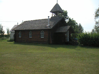
Watsons, built after a fire in 1909 on the property in Carcross


The area has a lot of nice lakes and scenery...

Bove Island in Tagish Lake


...and I enjoyed the scenery and swervery for a while before starting the climb to White Pass and cooler wetter weather. Some of the landscape is getting almost lunar in appearance.

Another lake further on, landscape looking quite different.


I passed the Canadian Customs post (they maintain a gap of about 10-15km between the US and Canadian posts and you only stop at the one) in cool drizzle and climbed into the cloud cover on White Pass. By this time it's quite cold, lots of snow about and the summit is completely shrouded in cloud, with viz about 10 feet, fogging to outside and inside of the visor. I made my way through this to the US post, cleared that and was immediately grateful to start descending out of the cloud and to warmer temperatures.
There were some spectacular ravines with views of the road as it winds around the mountains, and I made good time to Sakgway under brooding cloud and light drizzle. The town is at the neck of a steep fjord and feels quite closed in under low cloud.


Standing at the end of Skagway looking into the fjord the cruise ships come up


Skagway itself does not hold too much of the gold rush history, and it's really just a kitsch town for the cruise ships - there were 5 of them in at the time. I had a quick look around some of the shops, but it was all too expensive or too tacky, so I gave it a miss and headed back out.


There is a turnoff to Dyea, which was another major staging point for the gold rush. Stampeders arrived at Dyea and had to pack 1 ton of supplies over the Chilkoot Pass, some people taking up to 30 trips over the pass, including the infamous Golden Stairway. The road to Dyea is dirt and narrow, but absolutely beautiful. I continued right to the point where Dyea was - it grew from a tiny Tlingit settlement, to a town of over 20,000 people, but nothing remains of the town today. It sure is a beautiful place though.


The tidal river on the way to Dyea


On the return, the cloud had lifted a bit and I got some nice views from the White Pass summit and the surrounding countryside.

That line on the far hill is the road up White Pass


Nice ravine, low cloud and snow


Getting dizzy again


At the summit, had to duck for the low cloud!


Back to Whitehorse about 7:00pm for a Halibut and Sockeye Salmon dinner. Yum!

Time on the road, 8 hours, 417km.

Sunday, July 8, 2007

8 July Whitehorse


8 July
Whitehorse
. . . .
Up and about this morning, I take Bob and Louise out for breakfast and we spend some time touring some of the sights in Whitehorse.

Among some of the things we looked at, the dam and fish ladder at the top of town, too early for the King Salmon run unfortunately.


Miller Canyon, where the goldrush hopefuls navigated their boats and rafts


The dam has raised the water leve 20 ft fom the time of the gold rush, deep gorge!


The Beringia Centre and Transport Museum. Beringia is the bit of land that joined Russia and Alaska in the Ice Age.


Mastodon skeleton at the Beringia Centre


Also went by the sternwheeler SS Klondike

Klondike River at the top of Whitehorse looking North
...and from the same spot looking south

I found a bike shop that’s open Monday, so I’m going to try to get a tire. Successful or not, I plan to take a day run to Skagway, it’s 2 hours from Whitehorse.
Lay day for the bike today.

7 July Dawson to Whitehorse


7 July
Dawson to Whitehorse

. . . .


I spent a bit of time last evening strolling around Dawson, the city is all dirt roads and boardwalks, so it’s a bit interesting from that point of view. The place has pretty much the same feeling it might have had in the gold rush days, only without the crowds and the horsepoo. Coming into town from the north, you have to wait for a ferry to take you across the Yukon River, there is no bridge, the ferry just runs back and forth all day. I guess the volume of traffic does not justify a bridge, plus the danger of ice dams in the Spring washing any bridge away.

Did a bit of shopping and picked up some nice souvenirs.

This morning packed the bike with a bit of rain and got under way, not bothering to use the pannier water retaining system and trusting to copious supermarket bags to keep the contents dry. It was pretty much a transport run getting to Whitehorse, the only real highlights coming about mid afternoon when I came to Five Finger Rapids, a collection of rocky outcroppings in the river which complicated navigation nicely for the stern wheeler riverboats.

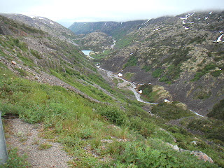
Five Finger Rapids on the Yukon River

That channel to the left of the largest island is actually the preferred navigation channel. It's about 10ft wider than a sternwheelr!


I decided airing the tyres down was not the best move I’ve made and break out the super you-beaut $7 compressor I scored from Canadian Tire and it does not work! Bum! And I’d taken the trouble to test it before I left Kelowna. Maybe it’s something in the accessory wiring I installed on the bike but I really doubt it. To make matters worse, the compressor is set up to release a bit of pressure as you attach and detach it from the tyre and now I have even lower pressure in the rear. I wobble and slide my way a few miles down the road to Carmacks hoping I don’t unseat the bead and find an air line at a garage (they hide them well) and sort it all out.

…and I left the air cap on the road back at 5 Rapids whilst faffing around with Canadian Tire’s finest equipment!

…and it’s pissing down!

30 psi front and rear turns the bike into something close to what it was before I started all this palaver and I bowl along into clear weather and reach some nice lake scenery and a few good views of the river and shingle cliffs.


Shingle cliff on the Yukon River
This whole area is one giant gravel pit left over from the glacier age and everything basically grows in a thin crust of dirt on top of the gravel.


Fascinating cloud formations


Fox lake


I had thought I would make the rear tyre last until Kelowna, but at today’s rate of wear I’m not going to make it. It’s Sunday tomorrow, so I’m in a bit of a quandary, but Louise tells me we’re doing a tour of Whitehorse tomorrow so I begin to rethink the plan. Many bike shops are closed Monday too, so I’ll sleep on it and just chill out tomorrow.

Time on the road, 8 hours, 520km, 30-ish km of road construction on fine gravel.
65/53mpg.

Saturday, July 7, 2007

6 July Taylor Highway and Top of the World Highway

6 July

Taylor Highway

Top of the World Highway


I woke this morning with a feeling of slight melancholy, today will be my last day in Alaska. All going well, I plan to cross the border on the Taylor Highway sometime this afternoon.
I hit the road at 9:30 after joining the Aguiars for brekky. Make any excuse you have to, but stay at Red Igloo Cabins at Gakona, Alaska. Sam and Viola are absolutely the salt of the earth. As long as you are there you are part of the family (and their family seems to extend to most of the district - I think they are Grandma and Grandpa to every kid in a 40 mile radius). Their cabins are first-rate for the price and very well set up. I had planned to go to Tok, a hundred-odd miles further on last night, but I had one of those days that put me on their doorstep. I guess everything happens for a reason.
Anyway, back on the road, the Tok cutoff road is paved and scenic and moderately twisty, so I had a reasonable time, except for the rain which got quite heavy at times. I made good time to Tok, spent half an hour doing some souvenir shopping, at the visitor centre,


Tok Visitor Centre


I gassed up and headed off for the Taylor Highway. I wanted to make the Top of the World Highway in good time, I, been told by everyone it was great, and Sam told me to stop off there and have a picnic.
The Taylor is windy and scenic and threads through rolling hillsides. There were reasonable views on the road because huge tracts of the forest had been burnt by bushfire a few years earlier and I stop off and check it out.

Taylor Highway


I wonder if this will work for the picnic?


The first part of the Taylor is paved, and the unpaved bit is mostly earth with a scattering of gravel. I'm making heavy weather of the dirt road, but persevere and reach Chicken, an old gold mining town. I had a quick look around, but didn't like it as much as I thought I would, so moved right along.


Gold dredge at Chicken, looking back from the Taylor
The story of how Chicken got it's name goes that the locals wanted to name it Ptarmingan, but no-one knew how to spell it.


The weather has heated up again and I have to take a few layers off and remove/replace rain covers to put it all away. The road becomes more gravelly and with a huge dropoff on my side of the road I go into wimp factor 7 Mr Sulu. I can't really understand this or enjoy myself right now. After a bit more of this and a little too much thinking, I decide I've been "riding the front wheel" since I put the new tire on. I take my own advice I give to my boys when coaching their riding and lift my gaze to the next corner and that seems to relax my deathgrip on the bars and the bike tracks better. That's good, but it's as if I've regressed in my riding and I have to focus on riding style in a way I haven't had to for years, fighting the countersteer instead of using it. I guess that spill rattled me more than I thought. Having bypassed Chicken, I figured I'd fill up on the last of the cheap Alaskan gas at Border, just before the um, border. However it turns out the Border folk have gone away for lunch/the day/ever and I can't gas up. Thank goodness for the jerrycans! Leaving Border, 9 miles from the border, the skies darken, oh joy! Just as I approach a mile to the Customs Post, a few fat drops of rain fall, enough to damp the dust, but not slick up the clay. Pulling up to wait for the inspector, it starts raining hard, then hail. I redeploy raincovers, then it's my turn and the inspector suggests we take it inside. After the formalities he says I can wait the rain out, it normally only lasts for 10 minutes at a time. I layer up again and take off shortly, with the rain a bit lighter, but where can I picnic in the rain and thunder? I'm on the Top of the World Highway now and aboot (in Canada now) 4-5 km further on I approach a summit there are still drifts of snow on some of the banks by the road. As I approach the summit, it appears to be covered with a dusting of snow (I've done this before) including the road! Turns out to be about an inch of hail on the road. Just as well I waited at the border post, I'd have been in that!


Ick!


Cool road (literally!)


Further on the rain thins and I come to a nice outcrop to have my picnic. My sausage heater has not worked to well, but I have a very late lunch anyway, which I'm halfway through when I realise a promintory is probably not the most intelligent place to sit while thunder and lightning is going on around me! I move down and a lightning strike seems to hit the next hill!

Thunderstorms!

I decide to bug out and make it to Dawson without having to refill from the jerry cans.

Both pannier covers now retain water, so I have a big drying session in my overheated hotel room.

Time on the road, 91/2 hours, 490km, about 120 km of dirt, about 250 km of rain.

5 July Denali Highway


5 July
Denali Highway

After a day of chilling, shopping and barbie-ing, I surfaced feeling a bit dizzy this morning. Doug took off for work earlier than planned, leaving the place to me and Jacqueline to close up after we'd packed and gone our separate ways. I don't think Doug's big on goodbyes.

I decided to get a new front tyre (I guess it's a tire if I buy it in this country), even though this one has another couple of thousand km, I have the Denali, Taylor and Top of the World Highways (gravel) in the next 2 days. I manage to find a decent tire :) Conti TKC80. Bike shops are funny about working on bikes they don't have the franchise for, so as this was not a Kawasaki dealer I was buying the tyre from, it was all very awkward until I offered to pull the wheel off myself!


Lovely noo tire for carving canyons and strafing shingle!


By the time it was all done, it was 11:30 before I hit the road. The bike feels a bit skittery with the new tire, can't decide if it's the worn rear, heavy load, or dodgy pressures. The run to Denali was straightforward enough, a stop in Nenana for a bit of cultural heritage and shopping, plus the odd photo.


Log Cabin church at Nenana


Nenana River, on the way to Denali National Park


Somehow it's 4:00pm before I get on the Denali Highway itself.


...and the sky I'm heading for looks awful dark. The surface is dirt with light gravel to start. After about 20 minutes the rain comes in and it starts to cool down, but still good travelling conditions and I'm making good time, congratulating myself on having the forethought to put all the luggage covers on at the last rip-off gas stop, nice apple danish though.

The bike is quite skatey on the gravel and it's about this time I realise that even though I'm now a gravel veteran (ha!), I have yet to travel any distance on gravel with a full load on the bike. I decide to try airing down the tyres, it seems to work better and I take off congratulating myself on the decision to get the new tire. It's really bucketing now and cooling right off. At about the halfway mark, the road has turned into clay with standing water. I get into a curve a bit hot and drift into the gravel berm, couple of tank slappers and I'm off the road into the bushes on my face. I'm OK but my foot is trapped under the right pannier and I waste what seems like ages finding the buried killswitch rather than go for the ignition switch right in front of me as the motor thuds away on its side. Thank goodness for roller bearing cranks! A few choice words and stopping to think gets me from under the bike after about a minute in the pouring rain and I'm just contemplating how to right the beast when a vanload of people stop and drag me back onto the road. "Go goddam slower" growls one of my rescuers. The bike is pretty much OK, so I get back on, only a tad slower with that warning reverberating in my head. This clay surface sucks in the wet. It lasts for about 40 miles and I'm getting a bit miffed that I took this road for scenery and all I get is 2 foot viz, a road perfect for mud wresting and damn cold to boot. The bike is handling weirdly, the front and back wheels are displaying an independance of motion I only like to see under a blouse and it's making for a long day. I hope I can get to the bottom of it soon, I don't fancy this fight for another 7 days.
At about the 2 hour mark, the rain lightens up and I begin to see some sky over the peak. (I realised a while ago I've been climbing for ages). As I approach the summit, the clouds start to clear and there are some stunning views looking back from where I've come.


no wonder I'm cold!


...and a little bit further on


I get to the end of the highway about 7:30 and grab a bit of food. My plan was to go South to the Tok cutoff road and jink north back up to Tok, another 125 miles further on. By the time I get to the Tok Cutoff Road I resolve to give up reaching Tok and start to look for accommodation. I end up at a place called Red Igloo Cabins, owned by a charming old couple who take me into their house, make me a cup of tea and tell stories. Viola celebrates her birthday today, so they'd just come back from her party down the road. Sam is a teller of tall tales and inveterate teaser, and I could have listened to him all night, but I made myself scarce after a while and settled into the cabin for the night.

I discovered the only damage from the spill, apart from a wee crack in the winscreen, was to the plastic container of trail mix I had in my tank bag. I now have a couple of stray nuts and M&Ms at the bottom of my bag, but I can live with that, it could have been much worse. I also found that one of my pannier raincovers retains water and bathes the bottom of the pannier in water long after the rain has passed. Great design, thank goodness for supermarket bags eh.

Time on the road, 10 hours, 503 km, 182 of it continuous dirt and snot.
63imp/50us mpg, I think the back wheel travelled further than the front, headwinds, and I know I spilled a bit when I tipped over.

Thursday, July 5, 2007

Itinerary South

4 July

Well, the place is closed today for Independance Day. I really need a new front tyre (sorry tire) so I spent the day in Fairbanks chilling, visting barbies and generally vegging out.

I'm taking off South tomorrow and thinking along these lines, give or take a day or so each way;

5 July, down to Denali National Park (again), across the Denali Highway and a bit of a jink down, then up to Tok
6 July, Tok to Dawson City over Tailor Highway and the Top of the World Highway
7 July, Dawson to Whitehorse via Klondike Highway
8 July, Whitehorse to Skagway
9 July, Skagway to Watson Lake
10 July Watson Lake to Stewart BC or Hyder Alaska via Cassiar Highway
11 July, Stewart to Prince George
12 July, Prince George to Kelowna.