Tuesday, July 17, 2007

12 July - Burns Lake to Kelowna

12 July
Burns Lake to Kelowna


Up and on the road by 9:30 after stopping for brekky at the local brekky place, (A&W I think). I’m 225 km west of Prince George and it took me 10 hours to do Kelowna to Prince George the first time, so I need to get on with it.
The road to Prince George passes uneventfully enough, although closer to 3 hours travel rather than the 2.5 I’d budgeted. The road is reasonably straight and uneventful and I don’t see much worth stopping for to photograph in my slightly hustle state of mind and I’m beginning to think that this will be a transport day. Hope not.
It’s unspeakably hot again and I’ve taken to wetting down my helmet liner for the past 2 or 3 days in an effort to get some temperature relief. It works well but I look like Dreyfuss when I take my helmet off and I have to remember to check out my appearance before approaching anyone.

After eating at Prince George and trying to find a speedo cable (sorry, order only – they bloody well had 2 KLRs on the floor! I was to repeat this experience 3 more times), I depart from my previous track and head due South towards Vancouver, my next waypoint being Cache Creek, 442 km away. The road is still rather straight and it's so hot that I’m drinking about half a litre of water every time I stop at this stage, mmmm warm water! I was to learn later that it had been 40 degrees for most of the day on the road I traveled.
I’m in the lake district and every second town seems to be called something lake. After about 2 hours travel, the scenery starts to get a bit interesting, a lot of mowing and haymaking going on, and down by Lac La Hache, some very nice countryside.


Bit of paradise by the water


In some places the countryside starts to remind me of a cross between Switzerland and Hawkes Bay. A bit later on the place starts to look a bit dry. To combat this there are extensive irrigation works with huge rotating arrays that pivot form a central point. As a result, many fields become circular (or semicircular where the well head is by the road).

Reminding me of home


Big irrigation works make for a circular green patchwork from the sky


At Cache Creek, the road changes from Highway 97 and becomes Highway 1 South to Vancouver. I intend to travel south to Spences Bridge and take a wee secondary road to Merritt. The road after Cache Creek becomes even more desertified and everything not cultivated is now straight Bush Sage. At this stage the road goes through Fraser Canyon and becomes very interesting for two wheeled travel.


Coming into Fraser Canyon

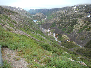
The canyon proper narrows right down and there are more of the superlong CPR trains, plus the odd ghost town feature


Across the other side of Fraser Canyon, ruined wooden church and CPR train


Constant companion


Looking up Fraser Canyon the way I've come


I have to go a bit further than I thought to catch highway 8 to Merritt where the road doubles back on itself up the other side of Fraser Canyon for a while, and it’s here that I’m pulled over by the RCMP for the first time. Just a random licence check by a couple of blokes in two cars, and it’s funny to watch the guys face as he clocks I’m foreign registered. He goes through the motions anyway, having stopped me and we talk a little about where I’ve been and where I’m going. He raises his eyebrows when he learns of my planned start and end points today, telling me “that IS a big day”, before wishing me well and telling me it’s been a pleasure having me visit his country. Awww.

So, buoyed up by this and the great road I have just ridden, I take off down Highway 8. Well, what a FANTASTIC piece of road, quite challenging and curvy, but with a nice reliable surface. I’m having so much fun carving it up I’m reluctant to stop to take pictures.

But I do


Gravel cliffs on Highway 8


Great road for a bike

The river valley Highway 8
Sounds corny I know, but at this stage the one thing going through my head was "Saved the best till last" This was the single best bit of riding in the whole trip.

I make it though to Merrit, and join Highway 97C, the Okanagan Connection, which is the main drag between Merritt and Kelowna, on the map it looks like a motorway. It’s only several days later I check the map to see the coy little legend “Closed in Winter”.

So, it’s a mountain pass.
No rain fortunately. Unfortunately, it rises so high and so steep, my ears pop several times within 10 minutes and the temp drops so much I have to stop and close off all the zips and vents in my riding suit. I think it went down to about 11 degrees at the summit.

And there was a genuine sunset, my first for nearly 3 weeks!


Coming down was exciting, very long steep grades, plus darkness, plus headlight plastered with flies plus tinted visor plastered with flies. Yes, I stopped and cleaned both of them off.

The rest of the ride into Kelowna was reasonably uneventful, except the traffic you always seem to encounter when approaching a major population center, plus the temp is back up to 30-something again. I got in at 10:30 and basically flaked out after ripping the luggage off the bike.

Time on the road; 13 hours
Distance 932km (how do those Iron Butt guys do 100 mile days?
Fuel, approx 51mpg imp, difficult to tell accurately without trip meter.

Total distance traveled in Canada and Alaska, 11, 500 km

Saturday, July 14, 2007

11 July Cassiar and YellowHead Highways


11 July
Rest of Cassiar Highway and most of YellowHead Highway


I got woken by some keen early riser at 4:30 this morning, so my own early alarm was duly ignored and I got to breakfast about 8:45, then spent a while chatting with other guests, then owners Tony and Mrs Tony. I spent a bit of time fault finding the electrics (fuse) and finally got lights working again and on the road at 11:00. 5km down the road and the speedo cable gives up the ghost! Curses, I use this to gauge my mileage, when to gas up, everything movement or distance related. Oh well, suck it and see. At least I have a couple of spare gallons, or nearly, I seem to have a bit of a leak from the $2.95 jerry can I got from Wally World, apparently it's self venting, which I think is legalese for can't guarantee the seal.
The weather is still cool with a bit of intermittent rain. Plenty of spectacular mountains, but so much cloud, not a lot of opportunity for photos.


After Iskut, there was a bit more road works, then the road turned beautiful, surface, scenery and curves.


As Professor Caluculus says; "A bit more to the west" fortunately the road does and I avoid weather.


I spotted a black bear cub by the road, but he beetled off quickly. A bit later I spotted another bear and finally got a photo, although not a great one, he only lifted his head to give me the evil eye.


Can't talk - eating


The worst of the weather is now behind me.


The view over the direction I am headed is looking clear, but I’ve been feeling a bit seedy all day and decide to give Stewart/Hyder a miss and see how close I can get to Prince George tonight. I am enjoying the road, though


although the weather is now really hot, like 32-36 degrees C.


By this time I've got to the end of the Cassiar Highway and I've joined the Yellowhead Highway which runs between Stewart and Prince George. Just before Moricetown, I get another headlight flash, the third of the day, the RCMP have been out in force this afternoon. But this is not just a speedtrap, there are full emergency services and all the drama, with a bunch of motorbikes pulled up at the scene. It seems a biker managed to miss a bend and get off the road bigtime, at least 20 ft off the road and almost to the cleared treeline. There was a gang of paramedics there doing what seemed to be dramatic stuff, so I hope the rider is OK.


In Moricetown itself I stopped for a breather at the Gorge, I'm in a bit of a dliema now. I need seat breaks but it's so hot I can't stop for more than a minute or two. The whole area is still under flood action after 3 weeks, all the rivers and creeks are torrents or very high.


Moricetown Gorge


It's ironic here that when the weather is hot, floods abound. There is still a lot of snow about to melt in the warmth.

I get into Smithers at 6:30ish and decide I need at least 2 more hours on the road, possibly 4 if I want to get to Prince George. Should eat, though, so I gas up and go to Maccas, which is really good not for the food, but for the air-conditioning. It's just after 7:00 by the time I'm back on the road, so I just go for it. At Houston I stop to check out the world's largest fly fishing rod,


...and decide maybe Fraser Lake might be my destination for the night, it's getting close to 8:00 and it's still 30+ degrees. I eventually end up at Burns Lake and a check of the book shows it's probably a better bet than Fraser, so I settle here for the night in a motel run by the local First Nation, so I got to pick up a nice souvenir hat. It's just over 2 hours from here to Prince George, so I should make Kelowna tomorrow.

Time on the road, 10 hours
distance, 617km
58mpg imperial - I think I pushed it a bit hard without being able to check my speed. I tried 3 bike shops in 3 towns over a distance of 400 km for speedo cables, but they were all order only - even though they had brand new KLRs on the floor. These guys are only really interested in quads and snowmobiles.

10 July, Cassiar Highway and 10,000km mark

10 July


Cassiar Highway (at least in part), and Stevie rackes up 10,000km on North American soil (literally!)


I arose early for a change to pack the bike up for a reasonable start. I bid fond farewells to Bob and Louise and made my way over to the bike shop to get the new rear tire by 9:00am. The place was in a bit of chaos with blocked hoists and other work, so once again several issues were resolved by me pulling the wheel myself.

After it was all back together I went to the local Tim Hortons for a quick breakfast, but it was not to be. There was a queue to start with, then a bloke at the table beside was an expat Kiwi living in Whitehorse, so we had a bit of a chinwag, then outside, a car stopped in the carpark to see if the NZ on the bike was for real, and they turned out to be Kiwis from San Francisco on holiday up north and very excited to find another Kiwi.
By the time this was all over, it was just after 11:00 that saw me riding out of downtown Whitehorse for the last time (this trip) and heading south down the Alaska Highway. Whitehorse is a relly nice town. There are only about 35,000 people in all of the Yukon Territory, and over 20,000 of them live in Whitehorse, but it's not too big.

I made reasonable time to Teslin, all the while worrying that I'd cocked up my distance calculations and needing to have been on the road a good 2 hours ago to achieve my goal of Dease Lake at a reasonable time. Nevertheless, I did stop off at the Tlingit Cultural Centre at Teslin, as I had yet to see much First Nation culture (except briefly at Nenana).


Totems outside the Tligit Cultural centre in Teslin


I wanted to buy an eagle ring but they were $200 and did not fit my hand that well, so I settled for a pewter eagle pin. Back over that dodgy long bridge with the steel mesh deck and just a transport run to the Cassiar Highway turnoff. I decided to eat and found myself at Sally's cafe, where I shared a table with the Alberta-based parents of the owners.
Back on the road, which is quite nice for scenery and swervery, and I had the kind of ride which reminded me more of NZ roads, although this part of the road was more swervery than scenery.


Close to the beginning of the Cassiar - looking promising so far, but them clouds is there waitin'


I managed to find some mountains and some weather,

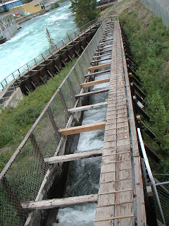
Waterfall at the very evocatively named 2nd North Fork Creek

Curves yay! Clouds boo!

but it was not too bad until the last 30km into Dease Lake, where the first bit of unpaved road (expected) came up, my favourite, wet clay which just covered me, the lights and the panniers with crap. Somewhere along this piece of road construction, I passed the 10,000 km mark for distance travelled in North America, but the enormity of the event was lost in the battle to stay rubber down. I managed to stay upright and sloshed my way to Dease Lake. ALL the accommodation people at Dease are ARSEHOLES. The place was full, but everyone would just point me to the next place when I asked where I should go, without bothering to tell me these places also had no vacancies.

The next point on the map (they are too small to be called towns), Iskut was 80+km down the road and one of the arseholes begrudgingly called ahead for me only to be told they were full too, hard luck. I gassed up and filled the cans in case I needed to pull an all-nighter. On the road again only to find my headlight is not working. Blow! I wonder how long that's been out? Looks fuse-related, maybe that's what the problem was with the compressor. It's getting important now because I'm far enough south that there is a bit of dusk when it's overcast. Not to mention the legal requirement for any vehicle to run headlights at all times in Canada. Oh well, the weather's too inhospitable and there is nowhere safe to stop now. I do spot caribou on the road, at one stage one of them loped along the road for a good kilometre and a half before I realised I needed to stop and give it a moment to get it’s stuff together and pick a place to wander off the road.
Moose's rear end

Not much opportunity for a good photo of the moose, but when I first came across it, it was stood in silhouette against the sky, just as if posing. I saw another a bit later down the same road, same pose and everything.


Pretty place when it's not bucketing down

I eventually get to Iskut and find a place with a room at 10:15. Whew! It's called Bear Paw lodge and is a huge chalet style building built by Tony from Austria back in 1991. It's a really nice place, quite upmarket for the middle of nowhere, but apparently when it was forst built there was huge traffic in hunting, fishing amd wolderness treks. It seems everywhere around here now is full from road construction crews and miners. I'm glad I found this place because I didn't fancy the tent tonight. Once I stopped, I realised that although the pannier water retention system has it's faults, it does keep road dirt and mud off the bags when the dirt roads are soaking. Now I have mud bags!


time on the road, 11hrs15, 652km, 70km unpaved. 60.85/50.2 mpg imp/us.

Monday, July 9, 2007

9 July White Pass to Skagway and Dyea


9 July

White Pass to Skagway and Dyea


. . . . . . .


Went to find a tire this morning and followed two blokes into a bike shop. They were two brothers from Iceland on a round the world trip on Yamaha XT660s and they wanted 4 tires. No joy there so we were sent off to the local Honda shop who had something for the boys and a tire that would do me. It's more street oriented than I would like (Avon Distanzia), but I have only about 70 more km of dirt programmed for this trip, and in this part of the world, you take what you can get if you don't want to wait a week. I arranged to get the job done tomorrow and took off for Skagway before the day got completely swallowed up.
The road out of Whitehorse is nice enough, and I'm enjoying the zip and nimbleness of an unloaded bike. Shortly I stopped at the first point of interest, Emerald Lake, a wee lake of the most dramatic green.


Emerald Lake


While I was there I got talking to an expat Kiwi who came to BC 50 years ago to go mountain climbing and never went home. I can understand, there are a lot of mountains


Me, a bike and mountains - yep, it's going to rain again!


I stopped in Carcross to check out the Yukon's oldest working General Store (since 1911).


Watsons, built after a fire in 1909 on the property in Carcross


The area has a lot of nice lakes and scenery...

Bove Island in Tagish Lake


...and I enjoyed the scenery and swervery for a while before starting the climb to White Pass and cooler wetter weather. Some of the landscape is getting almost lunar in appearance.

Another lake further on, landscape looking quite different.


I passed the Canadian Customs post (they maintain a gap of about 10-15km between the US and Canadian posts and you only stop at the one) in cool drizzle and climbed into the cloud cover on White Pass. By this time it's quite cold, lots of snow about and the summit is completely shrouded in cloud, with viz about 10 feet, fogging to outside and inside of the visor. I made my way through this to the US post, cleared that and was immediately grateful to start descending out of the cloud and to warmer temperatures.
There were some spectacular ravines with views of the road as it winds around the mountains, and I made good time to Sakgway under brooding cloud and light drizzle. The town is at the neck of a steep fjord and feels quite closed in under low cloud.


Standing at the end of Skagway looking into the fjord the cruise ships come up


Skagway itself does not hold too much of the gold rush history, and it's really just a kitsch town for the cruise ships - there were 5 of them in at the time. I had a quick look around some of the shops, but it was all too expensive or too tacky, so I gave it a miss and headed back out.


There is a turnoff to Dyea, which was another major staging point for the gold rush. Stampeders arrived at Dyea and had to pack 1 ton of supplies over the Chilkoot Pass, some people taking up to 30 trips over the pass, including the infamous Golden Stairway. The road to Dyea is dirt and narrow, but absolutely beautiful. I continued right to the point where Dyea was - it grew from a tiny Tlingit settlement, to a town of over 20,000 people, but nothing remains of the town today. It sure is a beautiful place though.


The tidal river on the way to Dyea


On the return, the cloud had lifted a bit and I got some nice views from the White Pass summit and the surrounding countryside.

That line on the far hill is the road up White Pass


Nice ravine, low cloud and snow


Getting dizzy again


At the summit, had to duck for the low cloud!


Back to Whitehorse about 7:00pm for a Halibut and Sockeye Salmon dinner. Yum!

Time on the road, 8 hours, 417km.

Sunday, July 8, 2007

8 July Whitehorse


8 July
Whitehorse
. . . .
Up and about this morning, I take Bob and Louise out for breakfast and we spend some time touring some of the sights in Whitehorse.

Among some of the things we looked at, the dam and fish ladder at the top of town, too early for the King Salmon run unfortunately.


Miller Canyon, where the goldrush hopefuls navigated their boats and rafts


The dam has raised the water leve 20 ft fom the time of the gold rush, deep gorge!


The Beringia Centre and Transport Museum. Beringia is the bit of land that joined Russia and Alaska in the Ice Age.


Mastodon skeleton at the Beringia Centre


Also went by the sternwheeler SS Klondike

Klondike River at the top of Whitehorse looking North
...and from the same spot looking south

I found a bike shop that’s open Monday, so I’m going to try to get a tire. Successful or not, I plan to take a day run to Skagway, it’s 2 hours from Whitehorse.
Lay day for the bike today.